
Basic research on the use of machine learning with satellite and other location data.
Why It Matters
Location-based data - i.e., GPS coordinates from your cellphone, the city a protest occurred in, or a satellite measurement - can all be integrated based on where the measurement happened, creating new 'mashups' of information. This represents an unprecedented opportunity for us to advance our capability to predict and understand, with immense datasets that can be used as inputs into machine learning approaches. However, using location data in conjunction with machine learning results in unique computational and statistical challenges, with limited research and guidance on how to overcome them. This page provides an overview of how we're innovating and applying AI and ML techniques to enable the use of location information.
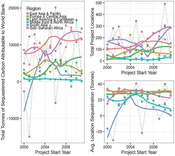
Counterfactual Reasoning with Spatial Data
| Peer-Reviewed Papers
| News & Briefs
| Code
Correlation isn't causation - but, what is? The most common scientific approach to quantitatively examining causality is "counterfactual analysis". In the medical community, we see this all the time - one group of people receive a pill, the other does not, and we contrast the outcome. The same concepts apply to satellite data - for example, if a number of locations implemented reforestation projects, and a number did not, we can contrast them to identify if the reforestation project was succesful. The use of spatial data in this way is relatively nascent in the field, and our research is contributing to basic research in both machine learning and GIS.
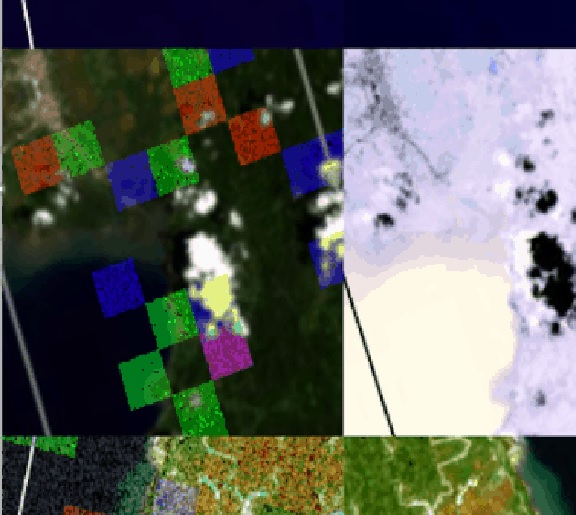
Deep Learning & Computer Vision
| Peer-Reviewed Papers
| News & Briefs
| Code
There is tremendous untapped potential in the use of deep learning and computer vision to extract information from satellite and aerial imagery. It has shown strong potential to help us to 'fill in the gaps' between surveys - for example, we may know from a mail survey the average income of households across 10% of communities in a country, and we can use satellite imagery and deep learning to make accurate predictions for the remaining. We focus on the big data infrastructure and algorithms required to apply these techniques to new substantive topics (including schools, conflict and more).
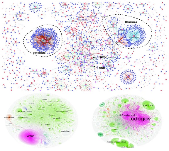
Network Analysis & System Modeling
| Peer-Reviewed Papers
Migratory patterns between places. Communication across Twitter. A wide range of human activities can be represented by networks, which are in turn nested within complex organizational structures which impact how networks will shift and change over time. We are at the forefront of extracting information from these networks, predicting future network states, and examining how to integrate novel types of data (i.e., satellite imagery) into network structures.